Maguiresbridge: Difference between revisions
No edit summary |
A.N. Other (talk | contribs) (→Rail) |
||
| (7 intermediate revisions by 2 users not shown) | |||
| Line 1: | Line 1: | ||
{{Infobox UK place | |||
|official_name= Maguiresbridge | |||
|irish_name= Droichead Mhig Uidhir | |||
|scots_name= | |||
|local_name= | |||
|static_image= | |||
|static_image_caption= | |||
|map_type= Northern Ireland | |||
|latitude= 54.295 | |||
|longitude= -7.465 | |||
|belfast_distance= | |||
|population = | |||
|irish_grid_reference= H347383 | |||
|unitary_northern_ireland= [[Fermanagh District Council|Fermanagh]] | |||
|country= Northern Ireland | |||
|post_town= | |||
|postcode_area= BT | |||
|postcode_district= BT94 | |||
|dial_code= 028, +44 28 | |||
|constituency_ni_assembly=[[Fermanagh and South Tyrone (Assembly constituency)|Fermanagh and South Tyrone]] | |||
|constituency_westminster= [[Fermanagh and South Tyrone (UK Parliament constituency)|Fermanagh and South Tyrone]] | |||
|lieutenancy_northern_ireland= [[County Fermanagh]] | |||
|website= | |||
|hide_services= yes | |||
}} | |||
'''Maguiresbridge''' ({{lang-ga|Droichead Mhig Uidhir}}) is a small village in [[County Fermanagh]], [[Northern Ireland]]. The village is named after the bridge (over the [[Colebrooke River]]) first built by the local Maguire family. | '''Maguiresbridge''' ({{lang-ga|Droichead Mhig Uidhir}}) is a small village in [[County Fermanagh]], [[Northern Ireland]]. The village is named after the bridge (over the [[Colebrooke River]]) first built by the local Maguire family. | ||
| Line 4: | Line 30: | ||
== Demographics == | == Demographics == | ||
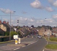
[[Image:Mainstreetmaguiresbridge.jpg|thumb|200px|Road leading into Maguiresbridge from Lisnaskea]] | |||
Maguiresbridge is classified as a small village or hamlet by the [http://www.nisra.gov.uk/ NI Statistics and Research Agency (NISRA)] (ie with population between 500 and 1,000 people). On Census day (29 April 2001) there were 774 people living in Maguiresbridge. | Maguiresbridge is classified as a small village or hamlet by the [http://www.nisra.gov.uk/ NI Statistics and Research Agency (NISRA)] (ie with population between 500 and 1,000 people). On Census day (29 April 2001) there were 774 people living in Maguiresbridge. | ||
| Line 16: | Line 43: | ||
== Transport == | == Transport == | ||
=== Rail === | === Rail === | ||
At the turn of the last century, Maguiresbridge was served by four different railway systems which stretched throughout Northern Ireland. Maguiresbridge and Clones were two of the major junctions from Derry, Omagh, and [[Belfast]] into north Leinster. | |||
Maguiresbridge Great Northern Railway station opened on 1 March 1859 and finally closed on 1 October 1957. This station also served as the western terminus of the narrow gauge Clogher Valley Railway. Narrow gauge traffic ceased on 31 December 1941. | |||
=== Bus === | === Bus === | ||
Latest revision as of 19:24, 19 January 2010
| Maguiresbridge | |
| Irish: Droichead Mhig Uidhir | |
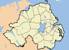
Maguiresbridge shown within Northern Ireland | |
| Coordinates: 54°17′42″N 7°27′54″W / 54.295°N 7.465°W | |
| Irish grid reference | |
|---|---|
| District | Fermanagh |
| County | County Fermanagh |
| Constituent country | Northern Ireland |
| Sovereign state | United Kingdom |
| Postcode district | BT94 |
| Dialling code | 028, +44 28 |
| European Parliament | Northern Ireland |
| UK Parliament | Fermanagh and South Tyrone |
| NI Assembly | Fermanagh and South Tyrone |
| List of places: UK • Northern Ireland • Fermanagh | |
Maguiresbridge (Irish: Droichead Mhig Uidhir) is a small village in County Fermanagh, Northern Ireland. The village is named after the bridge (over the Colebrooke River) first built by the local Maguire family.
Maguiresbridge is developing rapidly and with the construction of four new housing developments in the area totaling over 350 new properties. The population is now estimated to be over 1,500 as opposed to the 770 total in the 2001 Census. New shopping outlets have been constructed in Maguiresbridge to serve the growing population.
Demographics

Maguiresbridge is classified as a small village or hamlet by the NI Statistics and Research Agency (NISRA) (ie with population between 500 and 1,000 people). On Census day (29 April 2001) there were 774 people living in Maguiresbridge.
Of these:
- 25.5% were aged under 16 years and 15.6% were aged 60 and over
- 50.4% of the population were male and 49.6% were female
- 40.4% were from a Catholic background and 57.6% were from a Protestant background
- 6.9% of people aged 16-74 were unemployed
For more details see: NI Neighbourhood Information Service
Transport
Rail
At the turn of the last century, Maguiresbridge was served by four different railway systems which stretched throughout Northern Ireland. Maguiresbridge and Clones were two of the major junctions from Derry, Omagh, and Belfast into north Leinster.
Maguiresbridge Great Northern Railway station opened on 1 March 1859 and finally closed on 1 October 1957. This station also served as the western terminus of the narrow gauge Clogher Valley Railway. Narrow gauge traffic ceased on 31 December 1941.
Bus
- There is a town bus service that runs daily, and a night bus service at weekends. Both services serve the town's suburbs.
Education
Schools
- St. Mary's Roman Catholic Primary
- Maguiresbridge Controlled Primary
Religion

Churches
- Roman Catholic (Saint Mary's Church)
- Church of Ireland (Christchurch)
- Methodist Church
- Presbyterian Church in Ireland
