Aghadrumsee: Difference between revisions
No edit summary |
No edit summary |
||
| Line 27: | Line 27: | ||
}} | }} | ||
[[Image:Killyfole1830's.jpg|500px|left | [[Image:Killyfole1830's.jpg|500px|left]] | ||
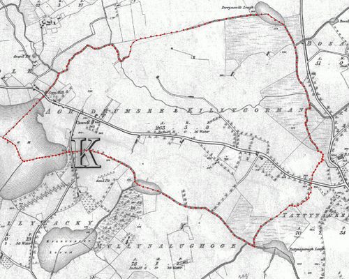
'''Aghadrumsee''' is a townland and a small village (aka [[Aghadrumsee Park]]) in South-Eastern [[wp:County Fermanagh|County Fermanagh]], [[wp:Northern Ireland|Northern Ireland]]. | '''Aghadrumsee''' is a townland and a small village (aka [[Aghadrumsee Park]]) in South-Eastern [[wp:County Fermanagh|County Fermanagh]], [[wp:Northern Ireland|Northern Ireland]]. | ||
Revision as of 22:55, 26 February 2012
| Aghadrumsee | |
| Irish: Achadh Droim Saileach | |
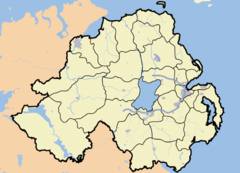
Aghadrumsee shown within Northern Ireland | |
| Coordinates: = 54°13′43″N 7°16′22″W / 54.2286°N 7.2728°W | |
| Irish grid reference | |
|---|---|
| District | Fermanagh |
| County | County Fermanagh |
| Constituent country | Northern Ireland |
| Sovereign state | United Kingdom |
| Post town | ENNISKILLEN |
| Postcode district | BT92 |
| Dialling code | 028 677 51 |
| Police | Northern Ireland |
| Fire | Northern Ireland |
| Ambulance | Northern Ireland |
| European Parliament | Northern Ireland |
| UK Parliament | Fermanagh and South Tyrone |
| NI Assembly | Fermanagh and South Tyrone |
| List of places: UK • Northern Ireland • Fermanagh | |

Aghadrumsee is a townland and a small village (aka Aghadrumsee Park) in South-Eastern County Fermanagh, Northern Ireland.
It is often referred to as Aghadrumsee and Killygorman
Etymology
- 1609 - Aghdromsillagh - Esch. Co. Map, 6
- 1613 - Aghdromsillagh 1 & third tate ( Sedborough manor M - CPR Jas I, 257a
- 1613? - Aghadromsillagh 1 & a third tat. (Jas I J.Sedborou - Inq. Ult. (Fermanagh), Car.1 $55 col.a
- 1613? - Aghe-Dromsyllaghe (Sudborroughe Edw' Sipthorpe) - Inq. Ult. (Fermanagh), Car.I $55 col.b
- 1613? - Ahadromsyllaghe (Sudborroughe Hug' McArt Maguire) - Inq. Ult. (Fermanagh), Car.I $55 col.a
- 1641? - Aghadromsilloughe (tenant Clynton Mawnd) - Inq. Ult. (Fermanagh), Car.I $55 col.c
- 1641? - Agherdromsilloughe (in poss' R.Allen & F.Teate) - Inq. Ult. (Fermanagh), Car.I $55 col.b
- 1641? - Aghi-Dromsilla cognoscitur per nomen de Aghadromsy - Inq. Ult. (Fermanagh), Car.I $55 col.c
- 1659 - Ashdrumsie - Census 1659, 100
- 1823 - Ahadrumsee - Church of Ireland Census
- 1833 - Achadh Druim Sídhe"field of the fairy ridge" - J O'D (OSNB), B133 B67
The earliest known spelling of Aghadrumsee is Aghadromsillagh.
This is derived from the Gaelic Agha (field),
[1]
Drom (hillock), [1]
Sillagh and roughly translates as 'field on the hillock of Sally trees'.
Further discussion on the Meaning of Aghadrumsee
Mythology
The ' see ' syllable in the current spelling of Aghadrumsee is a homophone of sidhe. This gives Aghadrumsee its folklore meaning of 'field of the fairy hillock.'
There is a local story of a black fairy dog (Púca), which shows itself to certain people. One story is of a local woman who was told the tale by some young men. The black dog only shows itself to the young men as they walked her home after attending a good Céilí. A good excuse to walk a pretty girl home, or do only true believers see the truth?
It is worth noting that this area has been known as "Black Dog's Lane", in the past. However, the exact location is more in the Drumswords townland, by the "March Ditch". Also, reports of ghostly black dogs are not uncommon in the British Isles.
1823 Church of Ireland Census
The following is an extract from a survey of the North-West Division of Clones Parish.
| Name | Sons | Daughters |
|---|---|---|
| Elliott, James | 0 | 0 |
| Elliott, Mary | 0 | 0 |
| Elliott, Margaret | 0 | 0 |
1841-61 Population
| Year | Persons |
|---|---|
| 1841 | 80 |
| 1851 | 49 |
| 1861 | 59 |
Black Dogs Lane
Black Dog's Lane & Black Dog's Dyke relate back to the ancient pallisade built in the Middle Ages to prevent invasion of Ulster from the South. The Black Dog's Dyke stretches from South Down through Armagh over to the Clones area.
Religion
Aghadrumsee comes under the Church of Ireland and Roman Catholic dioceses of Clogher. The parish of Aghadrumsee straddles the border town of Clones, County Monaghan in the Republic of Ireland.
The community is served by a number of churches and gospel halls.
Education
There are three primary schools, two Roman Catholic, Cornagague and Corranny, and one controlled – Aghadrumsee. All are sited in rural locations within three miles of each other and fall under the Western Education and Library Board (WELB) catchment area.
- Aghadrumsee Primary School - Controlled
- Cornagague Primary School - Council for Catholic Maintained Schools (CCMS)
- Corranny Primary School - Council for Catholic Maintained Schools (CCMS)
Historically, the current two storey building which is now attached to the orange hall was the old school at Aghadrumsee. In the Survey of Education in 1826 it was described as costing £120 and was funded by the Kildare Place Society. No figures for enrolment are given as it was not yet open.
The new school was built as a replacement in 1937. It was then enlarged and renovated in 1973-74 to take in children from Magheraveely and Roslea. The school now caters for children from a wide rural area.
Other schools in the local area, which are now closed, included Rateen National School.
Buildings of note
There is an Orange Hall at Aghadrumsee and another one at nearby Dromaddy.
Sport
The area also has a Gaelic Athletic Club called St Macartans Aghadrumsee which provides sport for both men and women. The local badminton team has a good reputation for skillful players.
Transport
Historically the town of Clones has had a significant influence on this rural community mainly due to the railway which used to go through it. The New Line.
Neighbouring townlands
Aghnachuill, Bosallagh, Crocknaboghill, Dernawilt, Drumswords, Killyfole, Killygorman, Killylackey, Mullynalughoge, Tattynageeragh
