Killyfole Lough: Difference between revisions
No edit summary |
|||
| (3 intermediate revisions by the same user not shown) | |||
| Line 38: | Line 38: | ||
Although no feedback was provided by the experts, local people believe it is currently in the Ulster Museum. The [http://www.killyfole.org.uk Killyfole and District Development Association] would very much like to learn what happened to this artefact and its current location as the dating of it could prove to be very valuable. | Although no feedback was provided by the experts, local people believe it is currently in the Ulster Museum. The [http://www.killyfole.org.uk Killyfole and District Development Association] would very much like to learn what happened to this artefact and its current location as the dating of it could prove to be very valuable. | ||
. | |||
==Corn Mill== | ==Corn Mill== | ||
[[Image:KillyfoleCornMill.JPG|thumb|left|Artists impression of the Corn Mill at Killyfole]] | |||
About 1800, there was one of the first man-made alterations to the landscape when the stream which came down [[Strananerriagh]] Glen was diverted into the western end of the lake. An embankment was built which is still known as "The Rampart" to provide more water power for the corn mill which was then built on the stream from the eastern end of the lough. | About 1800, there was one of the first man-made alterations to the landscape when the stream which came down [[Strananerriagh]] Glen was diverted into the western end of the lake. An embankment was built which is still known as "The Rampart" to provide more water power for the corn mill which was then built on the stream from the eastern end of the lough. | ||
This stream played an important part in the economic life of the area, powering first this mill, then the mills at [[Gortindarragh]] and the corn mill at [[Tonitybog]] which later became a spade mill. After joining with other streams to form [[Lacky]] River, it powered the spade mill there and the mill at [[Mullynavanogue]] and probably others before joining the Finn river near the Annie’s Bridge and entering an arm of [[wp:Lough Erne|Lough Erne]] near Wattlebridge. The outflow from the western end of the lough took a shorter route through all the loughs along the way to Moorlough and then on to Lough Erne near Derryadd, some seven miles nearer the [[wp:sea|sea]] than the other stream. | This stream played an important part in the economic life of the area, powering first this mill, then the mills at [[Gortindarragh]] and the corn mill at [[Tonitybog]] which later became a spade mill. After joining with other streams to form [[Lacky]] River, it powered the spade mill there and the mill at [[Mullynavanogue]] and probably others before joining the Finn river near the Annie’s Bridge and entering an arm of [[wp:Lough Erne|Lough Erne]] near Wattlebridge. The outflow from the western end of the lough took a shorter route through all the loughs along the way to Moorlough and then on to Lough Erne near Derryadd, some seven miles nearer the [[wp:sea|sea]] than the other stream. | ||
Latest revision as of 10:15, 17 August 2010
| Killyfole Lough | |
|---|---|
| Location | County Fermanagh, Northern Ireland |
| Coordinates | 54.2300, -7.2820 |
| Primary inflows | Strananerriagh Glenn |
| Primary outflows | Aghadrumsee & Loughgare Glenn |
| Catchment area | Townlands of Killyfole, Killylackey, Strananerriagh |
| Average depth | 9 m |
| Islands | 2 x Crannóg |
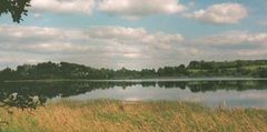
Where the townlands of Aghadrumsee, Killylackey, Killyfole and Loughgare meet there is a body of water known as a Lough. It is called "Killyfole Lough", but it often called the "Mill Lough" by locals, this is due to there being an old corn mill (See below).
The water in the Lough is coloured brown this is due to the catchment area of the Lough being mostly bog land, it is also sourced by underground springs. The springs proved to be a problem when the Lough was drained in order to become a reservoir.
For many years, prior to being used as reservoir, the Lough was a local beauty spot and beach. Local people recall many Sunday's being spent at the beach.
Crannóg

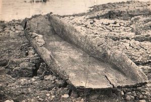
The earliest evidence of settlement in this area may have been the Crannóg which is located in the centre of the lough/lake. When the water level falls it becomes visible and was examined by experts when the lake was drained prior to becoming a reservoir. They believed this Crannóg was inhabited during medieval times. A hand crafted dug out boat was also found in the mud, the artefact was taken by the experts to be studied.
Although no feedback was provided by the experts, local people believe it is currently in the Ulster Museum. The Killyfole and District Development Association would very much like to learn what happened to this artefact and its current location as the dating of it could prove to be very valuable.
.
Corn Mill

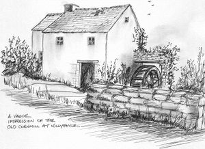
About 1800, there was one of the first man-made alterations to the landscape when the stream which came down Strananerriagh Glen was diverted into the western end of the lake. An embankment was built which is still known as "The Rampart" to provide more water power for the corn mill which was then built on the stream from the eastern end of the lough.
This stream played an important part in the economic life of the area, powering first this mill, then the mills at Gortindarragh and the corn mill at Tonitybog which later became a spade mill. After joining with other streams to form Lacky River, it powered the spade mill there and the mill at Mullynavanogue and probably others before joining the Finn river near the Annie’s Bridge and entering an arm of Lough Erne near Wattlebridge. The outflow from the western end of the lough took a shorter route through all the loughs along the way to Moorlough and then on to Lough Erne near Derryadd, some seven miles nearer the sea than the other stream.
The Killyfole mill ceased working in the 1930s and was used as a farm building until it was demolished around 1965 when the District Council developed the Lough as a reservoir.
The house at the crossroads was the original miller’s house occupied by Joseph Johnston in the Griffiths Valuation 1862. There were three different families of Johnstons who lived here and ran the mill. It has since been enlarged and modernised. Being on the side of the road, this was a well-known landmark and many a message or parcel was ‘left at the mill.’ In the farmyard wall was a red mail box.
Water Works
In 1968 the local water board acquired the lough and some surrounding land to build a new water treatment works. The lough was designated a reservoir and a fence erected around the perimeter of the Lough. A jetty was built which was used to pump water from the lough. The facility then processed the brown coloured water via a series of filter beds, chlorination tanks and then pumped the treated water up to a header tank on top of Carnmore mountain. This then gravity fed the local water mains. In 199?(8) the local authorises closed the water treatment works.
